Friday, April 6, 2012

5TH STOP..... THE END. ^ ^

BLUE RIDGE MOUNTAINS, USA. 
Back to the U.S.

Quick bites from the information brochure:
- location --> Shenandoah, National Park, Virginia, U.S.A
- formation --> the mountains began forming during the Silurian Period over 400 mil years ago. Approx. 320 mya, North America & Europe collided, pushing the mountains higher
- height --> 6,684 ft.
- most of the rocks that form the mountains are ancient granitic charnockites, metamorphosed volcanic formations & sedimentary limestones
- in 17th century --> native powhatan name for blue ridge was Quirank. Various tribes hunted & fished and the foot of the mountains
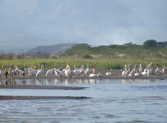
- many whitetail deers are found there.


Appalachians Range

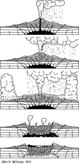
Formation of fold mountains

Contours of fold mountains. 

Sunset <3 

Flora & Fauna 


The Blue Ridge Mountains. Worth Dying For. :)
Quantity over Quality. Although it has only some mountains, not as much as other mountain ranges, the Blur Ridge Mountains make up in quality. 

peace. 


4TH STOP....

JAPAN. The Land of the Rising Sun.
"If the Japanese can't do it. Who can?"
Japan has suffered many earthquakes, some minor some major. We are looking at one earthquake in particular... one that occurred only last year. These are some things I learnt from the locals, some even told me of their traumatizing stories of death and survival...
Tohuku Earthquake, 2011
- Location: pacific coast of Tohuku
- Date: 11 March 2011
- Origin time: 14:46:23 JST
- Duration: 6 minutes
- Magnitude: 9.0
- Depth: 32 km
- Total damage: tsunami wave, flooding, landslides, fires, building and infrastructure damage, nuclear incidents including radiation releases
- Casualties: 15,854 deaths, 26,992 injured, 3,155 missing

--> Damage and impacts
 - PORTS: all of Japan's ports closed after the earthquake, 319 fishing boats + 10% of fishing ports were damaged
DAMS AND WATER: the Fujinuma irrigation dam in Sukagawa ruptured and caused flooding + washing away 5 homes, access to water was limited
- ELECTRICITY: 4.4 mil households deprived of electricity,
- OIL, GAS AND COAL: 220,000 barrel per day oil refinery of Cosmo Oil Company was set on fire by the quake, it was extinguished after 10 days - killing/injuring 6 people + destroying storage tanks
- NUCLEAR POWER PLANTS: many reactors were shut down, Fukushima meltdowns also caused a national state of emergency
- WIND POWER: none of the wind turbines, totaling 2300MW failed since it was hit as a result of the earthquake and tsunami
- TRANSPORT: transport suffered severe disruptions

--> Strategies 
- Planning the location of infrastructure
- Designing new infrastructure
- Strengthening existing infrastructure
- Education
- Earthquake monitoring & warning system

source: www.wikipedia.org

The Destruction..

The Debris...

The Aftermath.. 

The Fire. The Carnage :C 


3RD STOP...

THE EAST AFRICAN RIFT VALLEY.
After visiting the U.S., I had to board a plane that took me to Kenya - one of the closest places to the rift valley.
Before visiting it, I also took in the view of the rolling grasslands of Masai Mara and angelic sight of the shores of the Jade Sea. Oh yes... and a shopping spree. ; 0

Information broken down into digestible pieces by me finding out from the locals:
- The East African Rift Valley is an active continental rift zone in Eastern Africa (in other words, it's ALIVE)
- it was considered part of a larger Greater Rift Valley which extended all the way to TURKEY!
- it was formed from the divergence of 2 continental crusts - > the African Plate & Arabian Plate

The Journey
- I passed many lakes and when I glance into them, countless schools of fishes were swimming in them! Oh, it made me, more than glance, moments later. ;)
- INTERESTING FACT --> the fishes have evolved in such a way that they are able to live together without being in direct competition with each other (Could humans do the same? Frankly speaking? I don't think so...)
- Crabs, shrimps, copepods and ostracods were found there too! (One problem - HUMANS.  overfishing + shifting agriculture + pollution have threatened the existence of their species many times.)

source: www.wikipedia.org

Formation of the Rift Valley.

Flag of Kenya.


MAR-VE-LOUS.

What is happening... in picture.

Sunset at Masai Mara.

Masai Mara in the day. I had to drive off quickly after that... :p

The Jade Sea with one of its islands. Notice the different shades? You can literally see through the water!
IT'S THAT CLEAN AND PURE!

At one of the lakes.

One of the many streams...

THIS IS WHAT I MEAN WHEN I SAY I'M GOING CANOEING! 
This is Lake Malawi - the most southern lake of the East African Rift Valley.

A lasting impression that lasts for life. 
Kenya 2012. 

peacee. 


2ND STOP..

Its the 8th of March 2012. I'm standing on a footpath covered with snow.
What a change of scenery (and temperature)! From sunny Singapore to chilly U.S.
I am at the Crater Lake National Park.
Besides this panoramic park, the state of Oregon is absolutely stupefying. A must-go for anyone!
Here's some quick bites:
- location -> Oregon, U.S.
- established in 1902
- 5th Oldest National Park in the U.S.
- 9th deepest lake in the World
 source: www.wikipedia.org

Next uppp, photos! :)
This is basically how a crater lake is formed. (A picture speaks a thousand words, if you get what I mean)

Whoa. 

Sunrise. Beautifulll. 

I'd die to have winter, here in Singapore. 

The Administration Building window in winter. LOL.

Pretty much sums up the striking beauty of this crater lake. Will visit again in the summer to see what it's like! :)

Winter is amazing. Snow falling everywhere... if only I could live here! 
What I hope is that this winter snow won't melt off too much... due to global warming? :(
Al Gore, I salute you... please do carry on your work and change the world.

peace out once more ;)


FIRST STOP.

The date is 4 March 2012, and I'm on my way to scale Mount Saint Helens. 
Some background info about this glorious mountain that I was told by my guide :

- location -> Skamania County, Washington, USA
- an active composite volcano
- has a large eruptive cone consisting of lava, rock with ash and other deposits
- the rock is more than 40,000 years old
- the first person to conquer the mountain was Thomas J. Dryer in the year 1853
- the mountain is 8,365 ft. high
- the name 'Saint Helen' was derived from the English Diplomat, Lord Saint Helen (friend of the explorer George Vancouver)
--> Lord Saint Helen's real name? Alleyne Fitzherbert
--> Worked as 1. Minister Plenipotentiary to Russia
                        2. Chief Secretary to Northern Ireland
                        3. Member of Privy Council

- George Vancouver was a naval officer of the British Royal Navy. He was well known for his expeditions. Vancouver Island, Canada is an example of many places named after him.
He died on 10 May 1798 when we was 40 years old. Hats off to you explorer. :)

Source: www.wikipedia.org
Mount Saint Helens in all its glory.


18 May 1980 Eruption. The dark side of the mountain.
Explanation of the eruption.

Another beautiful picture. 

Besides the turbulence in the plane, tripping over a few rocks and getting dizzy from high altitude, the trip to the U.S. was just plainly awesome.
The dark side can't make see the mountain in a different light. It still reminds me of sunshine and rainbows. :) I'd remember the beautiful side over the eruptive side ANYTIME.
ON TO THE NEXT STOP - CRATER LAKE NATIONAL PARK. (also in the U.S.)

peace out.